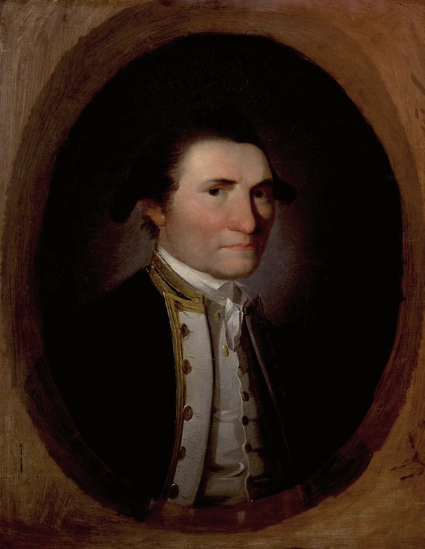
COOK, JAMES
1728 - 1779 from England
circumnavigator, was born on 27 October 1728 in the village of Marton-in-Cleveland, north Yorkshire, the son of James Cook (1694-1779), a day labourer, and his wife Grace, née Pace (1702-65). Cook spent most of his childhood in the nearby village of Great Ayton, but at the age of seventeen he went to work in a shop in the fishing village of Staithes on the north Yorkshire coast, where he remained for eighteen months. He then left for Whitby, where he became apprenticed to John Walker, a highly respected Quaker shipowner, whose ships were employed in the North Sea coal trade. Cook spent the next eleven years in these highly dangerous waters which were subject to violent storms, shifting sandbanks and uncharted shoals - a valuable lesson in seamanship and navigation that was to serve him well later in his career. In 1755 Cook was offered the command of one of Walker's ships, but instead, on 17 June 1755, he enlisted in the Royal Navy as an able seaman as he was determined 'to take his future fortune that way'.
Cook's abilities were soon recognised and on 29 June 1757 he passed the examination for master and thus became responsible for the navigation and handling of ships of the Royal Navy. On 26 July 1758, as master of the 60 gun Pembroke, he was present at the surrender of Louisburg in French Canada. The following day Cook went ashore where he met Major Samuel Holland, an army officer who was making a plan of the fortress with a plane table. Cook invited Holland on board the Pembroke to explain the use of this instrument. From this time Cook took an active interest in hydrographic surveying. The following June Cook was one of several masters of the fleet that surveyed and marked The Traverse, the principal hazard in the St Lawrence River, thus enabling the entire British fleet to pass safely through and attack Quebec. After the fall of Quebec Cook was appointed master of the 70 gun Northumberland, and during the next three and a half years surveyed Halifax Harbour, compiled sailing directions of the Gulf of St Lawrence and studied the theory of navigation. In July the Northumberland played a prominent part in the brief campaign leading to the recapture of St John's, Newfoundland, from the French, enabling Cook to carry out a number of important surveys, which led to his appointment as marine surveyor to chart the north and west coasts of Newfoundland. First, however, Cook returned to England in the Northumberland where he was discharged and where, on 21 December 1762, he married Elizabeth Batts in St Margaret's Church, at Barking in London.
On returning to Newfoundland in the early summer of 1763, Cook first surveyed the islands of Saint Pierre and Miquelon, which were to be restored to France. Over the next four years he surveyed the northern, western and southern coasts of Newfoundland in the specially purchased 68 ton schooner Grenville, spending the winter months back in London, working on his charts in his house in Mile End, returning to St John's the following spring. In 1766, with permission from the Admiralty, Cook began publishing his surveys and sailing directions, which were eventually incorporated in the famous North American Pilot, published by Sayer and Bennett in 1775. They remained in use for many years.

The First Voyage
When Cook returned to England in November 1767, the Royal Society was planning an expedition to the South Pacific to observe the transit of Venus across the face of the Sun, which would enable the distance between the Earth and the Sun to be calculated. The Admiralty, who were to provide the ship, insisted that it should be commanded by a naval officer, and so Cook was promoted lieutenant and on 25 May 1768 was appointed in command of the Whitby-built Endeavour of 336 tons, joining her two days later. Among the scientists who took part in the expedition were the astronomer Charles Green, appointed by the Royal Society to observe the transit of Venus, with Cook as the second observer, and Joseph Banks, a wealthy amateur botanist, bringing with him his own scientific team and artists. The island of Tahiti, whose longitude had recently been determined by Samuel Wallis, was chosen for the observation.
Cook sailed from Plymouth on 25 August 1768 and, after calling at Madeira and Río de Janeiro, passed well to the west of the Falklands, before rounding Cape Horn and anchoring in Matavai Bay on the north coast of Tahiti on 13 April 1769. After successfully observing the transit on 3 June, Cook sailed due south as far as 40°S to search for the great southern continent that geographers considered must exist in the Southern Ocean. Failing to sight land Cook then altered course to the west to investigate the land seen by Abel Tasman in 1642, eventually encountering the east coast of New Zealand on 6 October. Cook then spent the next six months carrying out a running survey of New Zealand's North and South Islands, during which he was able to determine his longitude with considerable accuracy by means of the newly-established method of lunar distances.
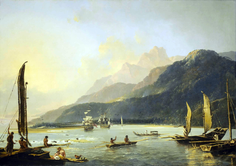
HMS Resolution and HMS Adventure with...
Cook next carried out a running survey of the unknown east coast of Australia in which his discovery of Botany Bay was to have a significant effect on the history of that continent. He then made for Batavia {Jakarta} in the Dutch East Indies for repairs. In sailing through Endeavour Strait Cook confirmed the discovery of Luis Vaez de Torres in 1606 that Australia was not joined to New Guinea as shown on most maps. Before his final departure from Australia Cook took possession of the whole of the east coast of Australia in the name of King George III, naming it New South Wales. After further calls at Table Bay and St Helena, Cook finally anchored in the Downs on 12 June 1771. During the voyage thirty members of the ship's company and Banks's party had died mainly due to illnesses contracted in Batavia. As a result of the success of the voyage Cook was promoted to commander on 29 August 1771.
The Second Voyage
In spite of the achievements of Cook's first voyage it was clear that there were vast areas in the Southern Ocean where a southern continent might still be found. Cook therefore proposed that a search for it should be made by circumnavigating the globe from west to east in a high southern latitude, thereby taking advantage of the strong prevailing westerly winds to be found there. Cook's plan was accepted and, as Endeavour had been sent out to Port Egmont with supplies, two further Whitby-built vessels were purchased and named Resolution and Adventure, Cook being given command of the former and Tobias Furneaux command of the latter. As a result of disagreements, Banks did not accompany the expedition, his place being taken by the German-born scientist Johann Reinhold FORSTER and his son George FORSTER. An important secondary aim of the expedition was to give extended trials to a copy of John Harrison's prize-winning chronometer H4 made by Larcum Kendall, known as K1, and three other chronometers made to the design of John Arnold.
Memorial to Captain Cook at Greenwich...
Cook sailed from Plymouth on 13 July 1772. After calling at Table Bay, he set a course to the south, and on encountering numerous tabular bergs, altered course to the east to begin his first ice-edge cruise. On 17 January 1773 he became the first person to cross the Antarctic Circle. On 9 February during an unsuccessful search in lower latitudes for land discovered by Kerguelen in 1772, the two ships became separated in a fog. When contact was not regained Cook decided to continue his sweep to the south before the onset of the southern winter, reaching Dusky Sound, in New Zealand's South Island on 27 March 1773, after a passage lasting four months without sighting land. He remained there for six weeks refreshing his crew and surveying this extensive inlet before rejoining Furneaux at the agreed rendezvous in Queen Charlotte Sound off the Canadian Pacific coast.
On 7 June, with Furneaux in company, Cook got under way and after an uneventful passage anchored on 26 August in Matavai Bay. He then spent the next two months working his way back to Queen Charlotte Sound through the Society Islands and Tonga. Off the east coast of New Zealand's North Island the two ships were struck by a severe gale and on 30 October became separated for a second time. After waiting in vain for three weeks for Furneaux in Queen Charlotte Sound, Cook sailed on his second ice-edge cruise. On 26 January 1774 he crossed the Antarctic Circle for the third time and four days later, at 71°10'S, 106°54'W, achieved his farthest south. Cook now decided to spend one more winter in the South Pacific so that he could explore the South Atlantic during the following summer. Making his way back to Tahiti, Cook anchored briefly off Easter Island, the first land to be sighted for 104 days. He next called at the Marquesas before anchoring once more in Matavai Bay on 22 April. After spending a few weeks in the Society Islands Cook set off once again for Queen Charlotte Sound, visiting Tonga for a second time and carrying out running surveys of the New Hebrides {Vanuatu} and the north-eastern side of New Caledonia. In Queen Charlotte Sound he learnt that Furneaux had arrived a few days after his departure and had sailed some days later. On 11 November Cook set off on the long voyage home, spending Christmas at anchor in the appropriately named Christmas Sound in Tierra del Fuego before exploring the South Atlantic.
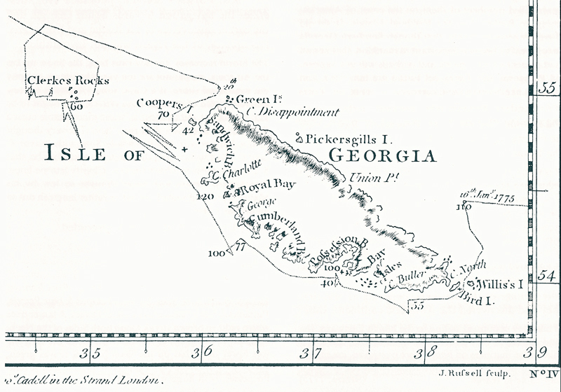
Cook's South -Up map of South Georgia...
South Georgia
After examining the north coast of Staten Island, Cook began his third ice-edge cruise. His intention was to continue his search for the supposed southern continent in the South Atlantic. To assist him he had a recently published chart by Alexander Dalrymple, which showed the tracks of Edmund Halley in the Paramore in 1700 and Jean-Baptiste-Charles Bouvet de Lozier in the Eagle(Aigle) and Mary( Marie) in 1739. Dalrymple's chart also showed an extensive coastline between about 53° and 63° South and between about 40° and 55° West of Greenwich, named Golfo de St Sebastiano, taken from Ortelius's map of 1586. At the northern end of this gulf, Dalrymple had charted Strait de la Roche and the track of Antonio de la ROCHE in 1675.
Although doubting the gulf's existence, Cook set his course from Staten Island towards its supposed western entrance so he could survey its coastline thoroughly should it be encountered. On reaching this position without sighting land, Cook then altered course northward to search for Strait de la Roche, whose existence seemed more likely as, according to Dalrymple, land had also been seen in this vicinity in 1756 by the Lion. The León, to give its correct spelling, was a Spanish merchant ship which was carried eastward from Cape Horn during a storm when on a voyage from Valparaiso to Spain. On 29 June the León sighted a small island and then more extensive land in 54°50'S, which remained in sight for three days. When there were no signs of land in the position assigned to the strait on Dalrymple's chart, Cook decided to run down its latitude and was rewarded, on 14 January 1775, by the sight of snow-covered mountains - the land now known as South Georgia.
Because of its mountainous appearance Cook thought the land to be extensive and decided to explore its northern coast, which he reached by passing through Stewart Strait, between Willis and Bird Islands off its NW extremity. He then coasted along its north coast until 16 January, when he anchored for the night. The following morning he stood in for the land and when an inlet was sighted, Cook decided to explore it in the hope of finding a suitable anchorage. A boat was lowered and, with Cook leading the party personally, the approaches were sounded, but the depths were too great and it was decided not to bring the Resolution in. However, Cook landed 'in three different places, displayed our Colours and took possession of the Country in his Majesty's name under a descharge of small Arms', naming the inlet Possession Bay. The Forsters, who accompanied Cook, found only three plants, while some seals were killed to provide fresh meat for the ship's company. Numerous seabirds were sighted and also the first sighting was made of the South Georgian Teal (Anas georgica).
Cook then continued working his way along the north coast of the island until eventually he rounded a point from where he could see that the land he had explored was only a medium sized island thus dispelling the hopes he had entertained that it might be part of an extensive continent. However, he confessed 'the disappointment I now met with did not affect me much, for to judge of the bulk by the sample it would not be worth the discovery. This land I called the Isle of Georgia in honor of H. Majesty'. He named the point Cape Disappointment, one of a number of Cook's names, including Cape Saunders, Cape George, Cape Charlotte and Cumberland Bay, which still survive. Cook made his departure from South Georgia on 20 January, commenting:

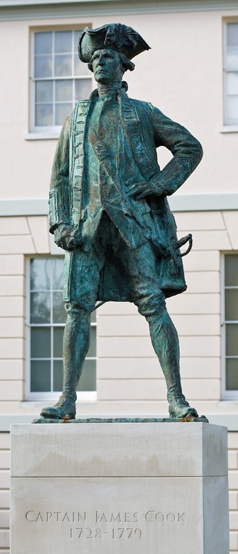
Britain's greatest navigator and...
The inner parts of the Country was not less savage and horrible: the Wild rocks raised their lofty summits till they were lost in the Clouds and the Vallies laid buried in everlasting Snow. Not a tree or shrub was to be seen, no not even big enough to make a tooth-pick.
On 23 January Cook encountered a group of rocky islets, situated between 35 and 40 miles ESE of South Georgia, which he named Clerke Rocks after Charles Clerke his second lieutenant. On 27 January ice was encountered and four days later land was sighted once again. Cook altered course to the north and, in foggy conditions, a series of islands and capes were sighted in the distance. After 100 miles, when no further land was sighted, Cook altered course to the east and then to the south, concluding the land he had sighted was either a group of islands or the tip of an icy continent, which it would be imprudent to explore. He named this partly explored land Sandwich Land, now the South Sandwich Islands.
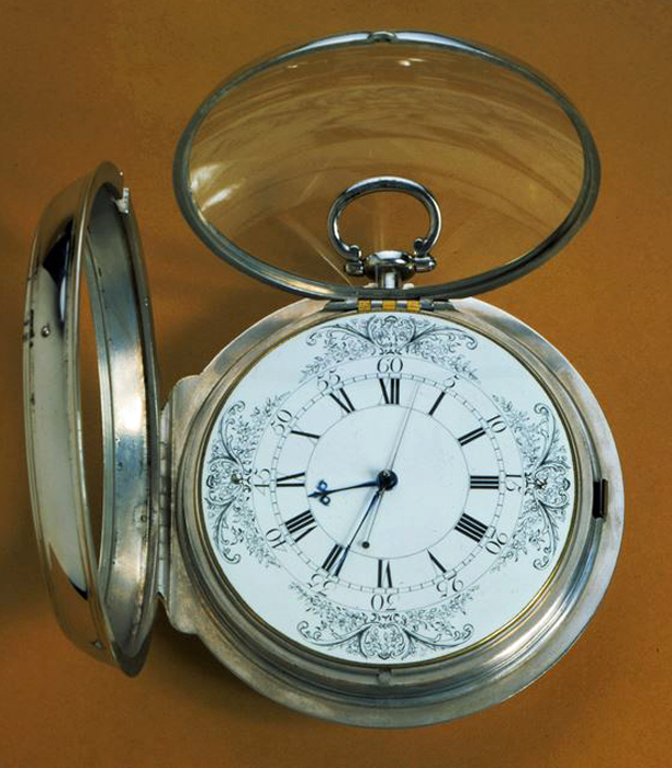
K1 Chronometer used by Cook on his...
After calling at Table Bay, St Helena, Ascension and Fayal in the Azores, Cook dropped anchor in Spithead on 30 July after an absence of three years and eighteen days, during which four men had died, but only one from sickness and none from scurvy - a remarkable achievement.
The Last Voyage
On his return to England Cook was promoted to post captain on 9 August 1775 and appointed Fourth Captain of Greenwich Hospital, a retirement appointment he accepted with the proviso that it would not preclude him from being considered for further service. In March 1776 Cook was elected a Fellow of the Royal Society and at the same time awarded the Society's Copley medal for his work on scurvy. Early in 1776 Cook was coaxed out of retirement to command a further expedition to the Pacific in an attempt to find a northern passage by sea from the Pacific to the Atlantic Ocean. Once again he was appointed to the Resolution with the newly purchased Discovery, commanded by Charles Clerke, as consort.
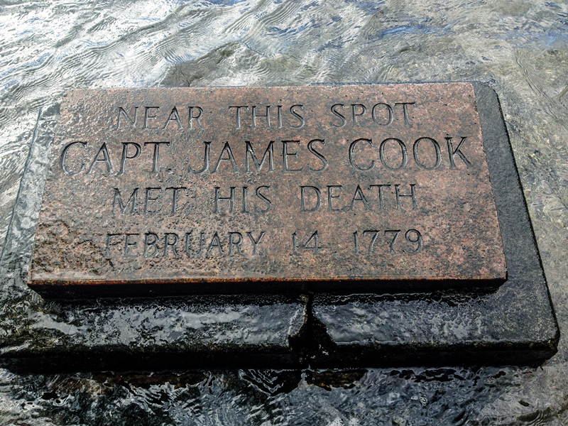
Captain Cook's memorial site
Cook sailed from Plymouth on 12 July 1776, anchoring in Table Bay on 18 October, where he was joined by the Discovery. On crossing the Indian Ocean, Cook carried out a running survey of the north coast of Kerguelen, establishing the island's longitude accurately with the aid of K1, which was once again carried on board the Resolution. After brief stops in Adventure Bay in Tasmania and his old anchorage in Queen Charlotte Sound, adverse winds forced Cook to call at Tonga instead of making directly for Tahiti. Eventually reaching the Society Islands, Cook continued across the Pacific, making his first major 'discovery' on this voyage when Oahu and Kauai, at the western end of the Hawaiian Islands, were sighted on 18 January 1778. Next the north-west coast of North America was sighted on 7 March and for the next six and a half months Cook carried out a running survey of some 4,000 miles of its coast from Cape Blanco on the coast of Oregon to Icy Cape on the north coast of Alaska, where he was forced to turn back by an impenetrable wall of ice. A search for a route back to Europe north of Siberia also proved fruitless.
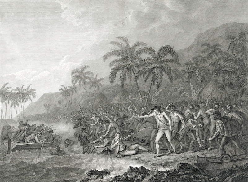
Cook decided to winter in the Hawaiian Islands, which he had named after his patron the Earl of Sandwich, before making a further attempt to find a northwest passage the following year. Cook anchored in Kealakekua Bay on the island of Hawaii on 17 January 1779. At first he was well received and by some accounts was considered by the Hawaiians as the embodiment of their God Lono. On 4 February 1779 Cook got under way to continue his survey of the islands but was forced to return to Kealakekua Bay for repairs after the Resolution's foremast was damaged in a violent storm. It soon became clear that his return was not welcome, culminating in the theft of the Discovery's cutter. On the morning of 14 February Cook landed with an escort of marines in an attempt, with less than his usual judgement, to persuade the local chief to return on board where he intended to hold him as a hostage against the return of the cutter. The chief readily agreed to accompany Cook, but at the landing place they were met by a hostile crowd and in the altercation that followed Cook and four of the marines were killed. Clerke, who now took command of the expedition, eventually managed to persuade the Hawaiians to return the majority of Cook's bones, which were put into a coffin and, on the afternoon of 21 February, were committed to the waters of Kealakekua Bay. Thus ended the life of Britain's greatest navigator and explorer.
There are numerous statues and monuments to Cook in many parts of the world, but the best memorial to him is the present-day map of the Pacific, which he did so much to shape.
External links
References
Glyndwr Williams; Captain Cook's voyages 1768-1779; published by the Folio Society; 1997
Comments
Revisions
May 2019 Map added
June 2019 Additional illustration added
July 2019 Additional photograph added; external link added; reference added
September 2020 Five additional photographs added